
See where we are now! Opens in new tab
Use this link to find us on a map updated every 10-30 mins depending on how we feel.(the page often stalls when loading; reload/refresh the page to complete opening the map)
The link will be active from 18 June 2016 when we leave Cairns.
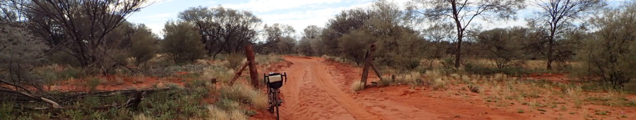
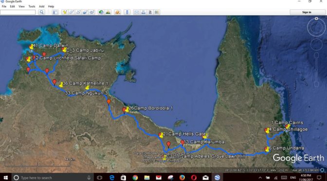
We will follow the Savannah Way across the bottom of the Gulf of Carpentaria. The map below shows the planned route, the loops are options to side track to national parks.

We will be following what was the original droving route from Queensland to the Kimberley in Western Australia. The current main highway is further south but lacks significant natural surface water.
The well-watered coastal route exposes drovers, and now bike riders, to diseases including dengue fever, malaria, encephalitis and Ross River fever. Large estuarine crocodiles that could easily take man, horse or bullock add interest to the creek crossings.
Our route will be about half on bitumen (tarmac) with the rest a reasonable gravel road. Hopefully the dirt sections will have been graded since the ‘wet’ season but not yet become badly corrugated by traffic. Most of the roads are a single lane so we will have to head bush when road trains (three trailer tracktor trailers) pass us.
- AA 09 June 2017 Getting close to the start of Creeks and Crocodiles
- AAA Cranking up for ‘Creeks and crocodiles’ tour from Cairns to Darwin
- AaaaaLlll Aboard! Transamerica
- Adding the new gear
- Day -7 14 July Starting the preparation
- Day 0 Cairns Darwin simplified route
- DAY 01 18 June Cairns to Kuranda
- DAY 02 19 JUNE KURANDA TO DIMBULAH
- DAY 03 20 JUNE DIMBULAH TO CHILLAGOE
- DAY 04 21 JUNE CAVING (IN) AT CHILLAGOE
- DAY 05 22 JUNE CHILLAGOE TO PINNACLE SPRINGS
- DAY 06 23 JUNE PINNACLE SPRINGS TO SUGARBAG TICK YARDS
- DAY 07 24 JUNE SUGARBAG YARDS TO UNDARA LAVA TUBES RESORT
- DAY 08 25 JUNE UNDARA RESORT AND LAVA TUBES TOURe
- DAY 09 26 JUNE UNDARA TO EINSLEIGH RIVER
- Day 1 2020 03 15 Hong Kong
- DAY 10 27 JUNE EINSLEIGH TO GEORGETOWN
- DAY 11 28 JUNE GEORGETOWN TO LITTLE RIVER
- DAY 12 29 JUNE LITTLE RIVER TO BLACK BULL
- DAY 13 30 JUNE BLACK BULL TO NORMANTON
- DAY 14 1 JULY NORMANTON TO KARUMBA
- DAY 15 2 JULY KARUMBA REST
- DAY 17 4 JULY NORMANTON AND THE GULFLANDER
- DAY 18 5 JULY NORMANTON TO WORKERS CAMP
- DAY 19 6 JULY TO LEICHHARDT’S FALLS
- DAY 20 7 JULY LEICHHARDT’S FALLS TO THE BURKE DEVELOPMENT ROAD – BITUMEN
- DAY 21 8 JULY TO GREGORY RIVER ON BITUMEN
- Day 21 Girls ride Roebuck Plains to Broome, Bruce rides out to meet them and misses 69 km
- DAY 22 9 JULY GREGORY RIVER TO LAWN HILL
- DAY 23 10 JULY LAWN HILL GORGE CANOING, RESTING
- DAY 24 11 JULY LAWN HILL TO ELIZABETH CREEK
- DAY 25 12 JULY ELIZABETH CREEK TO DOOMADGEE
- DAY 26 13 JULY DOOMADGEE TO HELLS GATE ROADHOUSE
- DAY 27 14 JULY HELLS GATE ROADHOUSE REST DAY
- DAY 28 15 JULY HELLS GATE ROADHOUSE TO (NEARLY) MASTERTON’S CAVE
- DAY 29 16 JULY Mastertons Cave to Surprise CREEK
- DAY 30 17 JULY SURPRISE CREEK TO ROBINSON RIVER
- DAY 31 18 JULY ROBINSON RIVER TO 45 KM FROM BORROLOOLA
- DAY 32 19 JULY TO BOROLOOLA
- DAY 33 20 JULY BORROLOOLA TO KING ASH BAY FISHING CLUB
- DAY 34 21 JULY KING ASH BAY REST AND RIVER JAUNT
- DAY 35 22 JULY RETURN TO BORROLOOLA
- Day 36 23 July Borroloola to Batten Creek
- DAY 37 24 JULY BATTEN CREEK TO (ALMOST) SOUTHERN LOST CITY
- DAY 38 25 JULY SOUTHERN LOST CITY TO BUTTERFLY SPRINGS
- DAY 39 26 JULY BUTTERFLY SPRINGS TO COX RIVER
- DAY 40 27 JULY COX RIVER TO TOWNS RIVER WITH MANDARINS
- DAY 41 28 JULY TOWNS RIVER TO MOUNTAIN CREEK
- DAY 42 29 JULY MOUNTAIN CREEK TO ROPER BAR
- DAY 43 30 JULY RESTING AT ROPER BAR
- DAY 44 31 JULY ROPER BAR TO MOLE HILL
- DAY 45 1 AUGUST MOLE HILL TO MATARANKA – Snorting in the night
- DAY 46 2 AUGUST REST AND SWIM AT MATARANKA AND MEET BROTHER PETER
- DAY 47 3 AUGUST MATARANKA TO KATHERINE
- DAY 48 4 AUGUST KATHERINE. SOME GO TO THE GORGES AND SOME JUST GORGE
- DAY 49 5 AUGUST KATHERINE TO PINE CREEK
- DAY 50 6 AUGUST PINE CREEK TO MOLINE WATERHOLE IN KAKADU NATIONAL PARK
- DAY 51 7 AUGUST KAKADU MOLINE WATERHOLE TO MAJUK (BARRAMUNDI GORGE) FALLS
- DAY 52 8 AUGUST MAJUK FALLS TO COOINDA KAKADU RESORT
- DAY 53 9 AUGUST KAKADU COOINDA RESORT CROCODILE TOURS, ABORIGINAL HISTORY AND ICE CREAMS
- DAY 54 10 AUGUST JABIRU MORE ABORIGINAL LORE
- DAY 55 11 AUGUST LEAVING KAKADU, MOUNT BUNDY AND GUNS
- DAY 56 12 AUGUST MARRAKAI CROSSING AND THE CROCODILE WITHOUT A CLOCK
- DAY 57 13 AUGUST BATCHELOR
- DAY 58 14 AUGUST LITCHFIELD NATIONAL PARK AND FLORENCE FALLS
- DAY 59 15 AUGUST CROCODILES, RAGING RANGERS AND SPRING FALLS
- DAY 60 16 AUGUST A LIFT OVER THE CROCODILES, SAND AND PAST TIPPERARY STATION TO THE LAST WILD CAMP
- DAY 61 17 AUGUST BATCHELOR AGAIN
- DAY 62 18 AUGUST WANGI FALLS
- DAY 63 19 AUGUST LEAVING LITCHFIELD NATIONAL PARK TO BERRY SPRINGS
- DAY 64 20 AUGUST 20 PAST HUMPTY DOO AND THE SPECIAL CAMPSITE AT COOLINGA
- DAY 65 21 AUGUST THE ORCHID FARM, JAM AND SCONES, THE LAST NIGHT
- DAY 66 22 AUGUST DARWIN !!!!!! ITS OVER
- day 66.5 22 AUGUST DARWIN!!!!! ITS OVER
- DAY 67 AND ONWARDS EPILOGUE